ArcGIS GeoEvent Server enables real-time data visualization and analysis capabilities for data streams to be integrated as data sources in your ArcGIS environments. ArcGIS GeoEvent allows for the use of filters and processors to build into Services that link input and output connectors. Input connectors help in identifying how the data is being received, along with how the data is formatted. While output connectors are responsible for preparing and sending processed data through different communication channels (system file, HTTP, TCP, UDP, WebSocket, and Esri feature service). To learn more about available output connectors, visit the overview page for official documentation. GeoEvent offers a variety of customizable GeoEvent Services, allowing users to define the flow of event data, with the ability for real-time filtering and processing as data moves through GeoEvent services.

Image from Esri
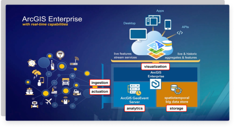
ArcGIS GeoEvent provides 5 core capabilities for your data, including ingestion, analytics, storage, visualization, and dissemination/actuation. Ingestion can best be described as the process of bringing in big data at a high velocity. After data has been obtained, users can then perform real time analytics to target and learn from key areas of interest. Data moving through GeoEvent services can then be stored in a variety of ways, including ArcGIS Enterprise or ArcGIS Online environments, or even stored in a spatiotemporal big data store. Once data has been brought in and analyzed, you can display this information through a variety of GeoEvent output options. And the last step is actuation, the process in which the information goes out, and is received in real time.
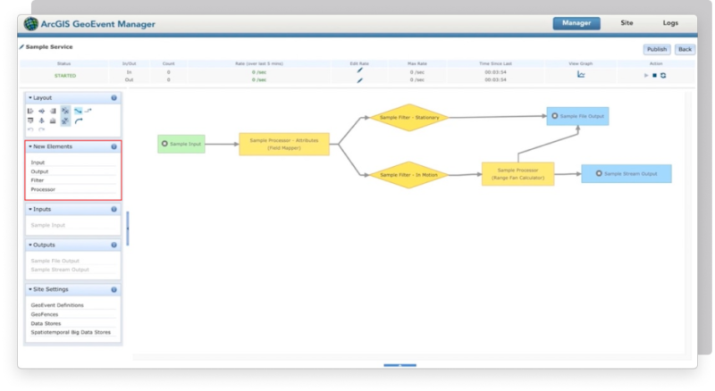
Users have the ability to create input connectors and output connectors, linking them to create and publish GeoEvent Services. Connectors provide users with the ability to connect to a variety of data sources to build GeoEvent Services that provide the most up to date information as it occurs. Processors are configurable elements that perform specific actions on event data as it’s received, including the identification or enrichment of data as it’s directed from inputs to outputs.

Image from Esri
Examples of processors include the GeoTagger processor, which uses GeoFences to dynamically add location information as data comes in. The Buffer Creator processor is used to create a buffer around an event’s geometry. And the Intersector processor which is used to represent the intersection between a geofence and a geometry. Explore the full list of processors that ArcGIS GeoEvent Server offers.

Image from Esri
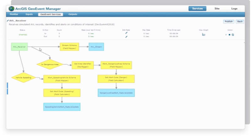
GeoEvent allows for multiple streams of real-time data to be analyzed and monitored for specific metrics in order to trigger events, such as a text or email when a wildfire has been detected in a specific area. Once these patterns of interest have been determined, or when the specific criteria has been met, then alerts can be automatically sent across multiple channels to inform whoever may need this real-time information.
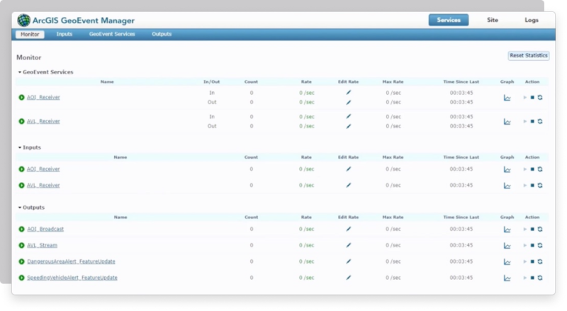
For administration purposes, ArcGIS GeoEvent Manager is used to create Inputs, Outputs, and Services, and to monitor event record counts for ingesting, processing, and relaying information that is relevant to your GeoEvent Services. Creating and managing inputs, outputs, along with the design and publishing of GeoEvent Services are some other capabilities that you have as an admin.

Image from Esri
Find the latest content available for GeoEvent Server by exploring the Gallery for connectors, processors, tutorials, apps and more. For more information on how to get started with ArcGIS GeoEvent Server, dive into the Starter Guide to view step-by-step tutorials that will help you get started with GeoEvent Server.
Are you ready to take full advantage of GeoEvent Server for real-time awareness and analysis? Check out our previous blog post for more great information about GeoEvent Server. And don’t hesitate to reach out to our industry experts to start a conversation today, and see how GeoMarvel can help you start using the power of ArcGIS GeoEvent Server.