Is your organization in need of a solution that integrates real-time, event-based data streams as data sources into your Enterprise ArcGIS account? Look no further – Esri’s ArcGIS GeoEvent Server has all of the answers for you.

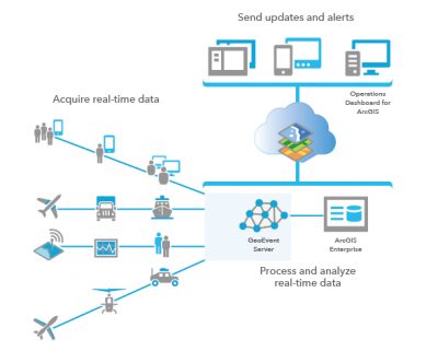
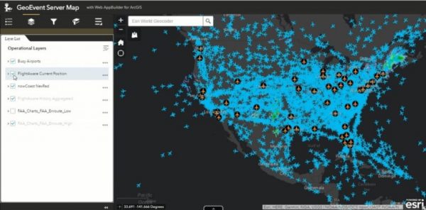
ArcGIS GeoEvent Server offers a solution for organizations like yours to filter, process, and distribute data to multiple destinations in real-time, while promoting connectability with any form of streaming data to alert personnel when specific events occur. This solution transforms standard GIS applications into front-line decision-making tools, advocating faster response times and increased awareness whenever and wherever a change takes place. GeoEvent Server consumes event data from multiple real-time data streams, with filters that allow analysts to focus on the most important events, locations, or thresholds at any given time. Additionally, through GeoEvent Server, event data can be streamed to client-side applications, while also directing the data into feature services hosted on ArcGIS Online, Portal for ArcGIS, or ArcGIS Server, promoting map relevance with up-to-date information as it is collected.
GeoEvent Server is already being used widely across the world by emergency departments, public utility organizations, risk management teams, and now even sporting events. In Seattle, WA, the police department created a high-tech crime center that helps officers, investigators, and analysts respond rapidly to crime scenes while solving crimes more efficiently and effectively. The crime center updates every six seconds with updates on active 911 calls using GeoEvent Server. The information is used to make informed decisions on how to best deploy resources and aid officers on the ground as incidents occur in real time.


For this year’s Boston Marathon, an ArcGIS GeoEvent Server was used to feed real-time data into the Marathon’s Dashboard, while also ensuring situation awareness. Trackers and numbers were given to over 30,000 registered runners to clock their times and locations throughout the race. The trackers would register with mats placed along the course at five-kilometer increments, which pushed information into a feature service using GeoEvent Server, keeping accurate data streaming into the Marathon Dashboard for over half a million spectators to follow along throughout the event.
Another compelling use for ArcGIS GeoEvent Server lies with health monitoring programs like Life Alert and home security systems like ADT. Imagine if the clicking of a Life Alert device or an alarm signal for a home burglary or smoke alarm would stream location data across a GeoEvent Server dashboard hosted by local authorities in real time instead of submitting phone calls to agency representatives. Cutting out the extra step could make all of the difference when it comes to saving lives.

ArcGIS GeoEvent Server is a licensing role of ArcGIS Server – a component of the ArcGIS Enterprise platform. GeoEvent Server licensing enables all real-time data intake, analysis, visualization, and notification capabilities for your enterprise.
Interested in learning more about ArcGIS GeoEvent Server features and usage? Contact one of our experts at support@geomarvel.com to learn more about how you can begin implementing these cutting-edge tools into your lines of business today!