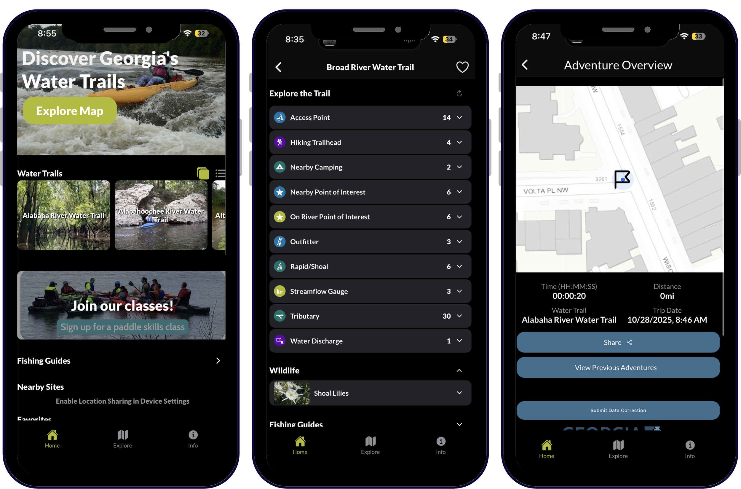
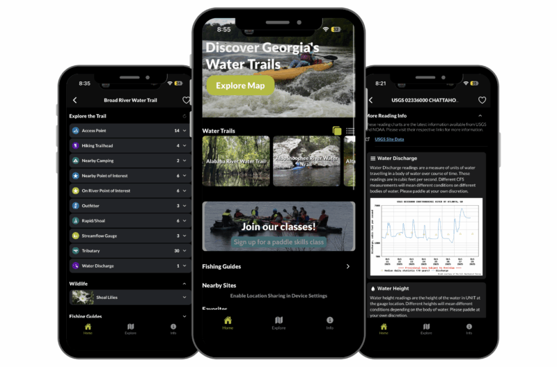
GeoMarvel is proud to contribute to the development of Georgia River Guide, a free application that provides users with access to interactive safety and logistical information about dozens of water trails and their related amenities and features throughout Georgia’s rivers. With the Georgia River Guide app, paddlers are emboldened to traverse water trails across the state, knowing they have the power of comprehensive data in the palm of their hands. From trail length and difficulty to typical paddling season, paddlers can view key features and descriptors of each trail, along with its available sites and amenities for trip planning.
This intuitive application has provided trip planning and site-specific details about safety and water conditions to Georgia’s paddlers for years. Paddlers can also leverage information about nearby amenities and local attractions, view accesses, obstacles, and camping options for trails on a map, giving them a holistic perspective for planning their journey. From the ability to access data in offline environments to an easy-to-navigate user interface, this app provides a cutting edge digital experience dovetailed with the most vital and valuable knowledge for dozens of Georgia’s trails.
The 2025 update gives users even more power to safely plan their trips, providing live safety information for water trails and their related sites in an interactive format. Now Georgia’s paddlers can also see:
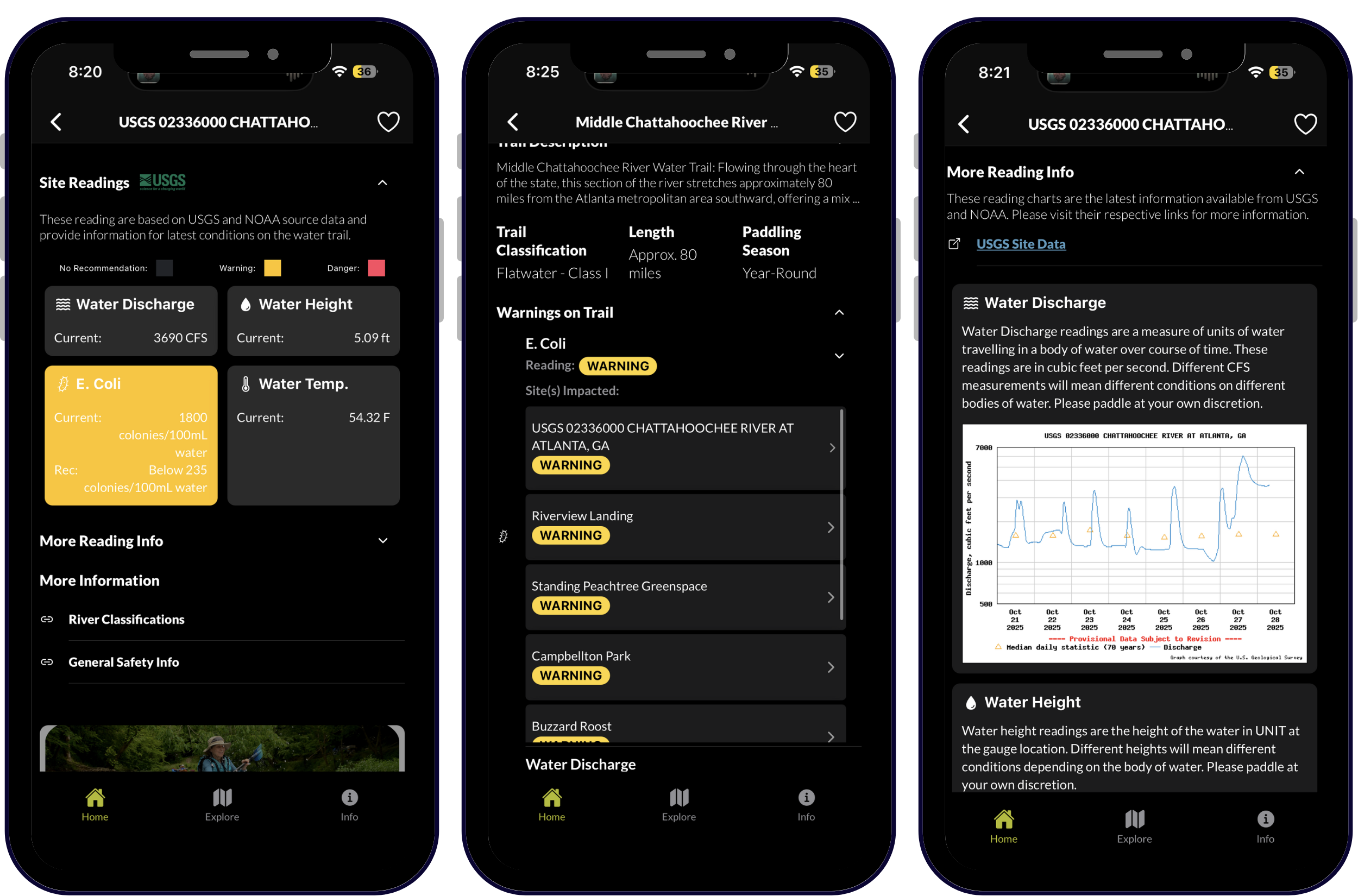
With recommended ranges for recreational activity, users can easily assess warnings and dangers these readings may pose. Data is live and is pulled directly from authoritative sources, such as the National Oceanic and Atmospheric Administration (NOAA) and United States Geological Survey (USGS), incorporating readings specifically relevant to water trails and their sites. Users can not only access an overview of any warnings or dangers on a chosen water trail, but also see specific sites impacted along the trail.
This functionality allows paddlers to quickly review given hazards and their severity, and dive deeper with graphs and predictions of conditions over time, as well as navigate directly to the authoritative data provider for more detail. Georgia River Guide also highlights the dams located along Georgia’s trails and provides users the ability to retrieve authoritative dam release schedules from US Army Corps of Engineers (USACE) and Georgia Power based on dams specific to each trail.
Georgia Rivers is a statewide 501(c)(3) nonprofit focused on protecting Georgia’s waterways and connecting people to them through recreation, education, and advocacy. As the Georgia Department of Natural Resources’ (DNR) nonprofit partner, it manages the Georgia Water Trails Network, maps rivers, and offers the free Georgia River Guide app. The organization also leads paddle trips, kayak training, and the week-long Paddle Georgia adventure to foster connection with the state’s rivers.
Formed in the late 1990s by paddlers concerned about river degradation and weakened protections, Georgia Rivers has spent over 25 years expanding public access, building community, and advancing grassroots conservation and advocacy across the state. Today, Georgia Rivers continues to connect people, policy, and place. It serves as fiscal sponsor for key coalitions, including the Georgia Water Coalition and Okefenokee Protection Alliance, and works to ensure Georgia’s rivers remain healthy, accessible, and valued for generations to come.


The Georgia River Guide mobile application is built using Ionic React, an open-source, cross platform development kit. The application leverages the Node.js runtime and Ionic CLI. To display online and offline maps the application uses Leaflet.js, an open source JavaScript library that allows for a number of plugins, such as esri-leaflet. ArcGIS Online is home to the Hosted Feature Layer that contains the applications sites and water trails data layers along with an assortment of related tables containing data on wildlife, sponsors and resource links.
Is your organization ready to bring a mobile application idea to life? Or perhaps you’re seeking other Professional GIS Services? Explore all of our professional services, and read up on our past successes outlined in our diverse portfolio. Reach out to our industry experts to start a conversation about your unique needs today.