It is with great excitement that we announce another land preservation venture with our partners at STACH PLLC. They’re a preservation landscape architecture and planning firm based in Asheville, North Carolina, with an extensive project portfolio that includes historic sites like President Lincoln’s Cottage, restoration of historic designed landscapes like the DC World War I Memorial, preservation of ethnographic landscapes including the Alamo Preservation Master Plan, among many others.
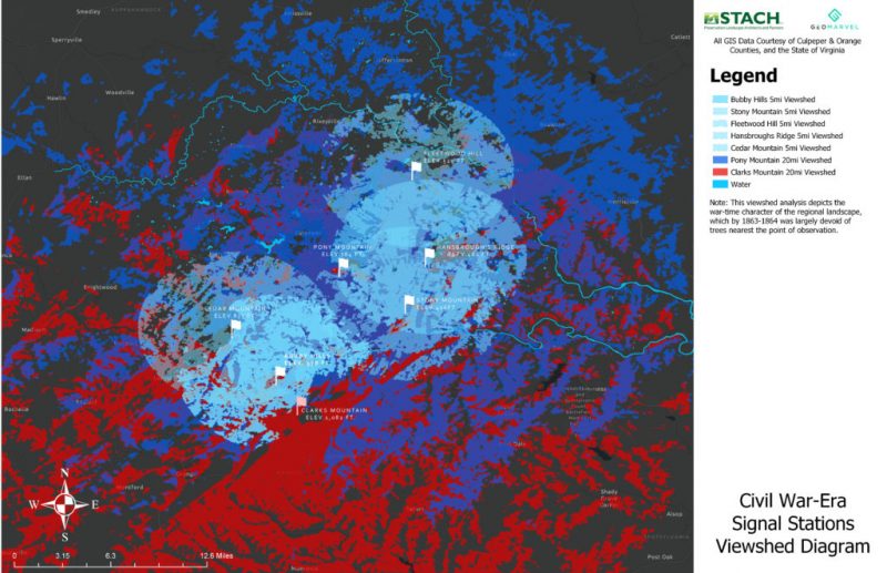
This latest land preservation effort involved performing in-depth viewshed analysis for historical land preservation for seven different mountain points that served as signal stations and were key influences during the course of events, occupation, and military conflicts across the Culpeper, VA landscape during the Civil War. These viewshed diagrams will be used by the American Battlefield Protection Program as a continuation of its coalition efforts to promote the significance of various battlefield grounds and occupation regions of both armies.

Culpeper County’s rural landscape is rich in history, ecological splendor, and affords some of the most iconic views of the Virginia Piedmont. The region was also very integral during the Civil War, serving host for many military conflicts and occupations between the years 1862-1864, including the initiation of eight military campaigns, six nationally-significant battles, and many hundreds of acres of military encampments, posts and pickets. Additionally, Culpeper offered a complex large network of historic views and observation points (known as signal-stations) that served as both communication and intelligence positions during the Civil War.
“This interrelated network of views and viewsheds deserves continued scholarship, and consideration,” the Trust announced. “Most frequently, battlefield preservation focuses its attention to safeguard lands ‘where blood was shed,’ lands often referred to as Core Battlefield, therefore, less attention is apportioned to interpreting or protecting a battlefield’s associated, and contextual viewshed.”
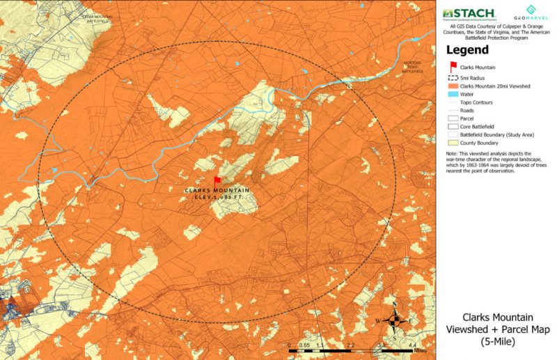
Case in point, Culpeper’s network of war-time signal stations lie atop many of its most visible and iconic hills and mountains, yet most fall outside of lands identified as Core Battlefield; however, these key observation points and their scenic views are considered “a contributing and character-defining feature” of the historic landscape, and warrant continued stewardship and preservation. Today, the American Battlefield Protection Program owns land atop two of Culpeper’s prominent hilltops at both Hansbrough’s Ridge, and Fleetwood Hill. Their views today offer a deep look into Culpeper’s historical past, and necessitated some core GIS work to create and develop viewshed analysis for each of the Trust’s identified signal stations, including: Clark’s Mountain, Cedar Mountain, Fleetwood Hill, Hansbrough’s Ridge, Pony Mountain, Stony Mountain, and Bubby Hills.
To create these maps, we leveraged some of the ready-to-use tools offered in ArcGIS Pro for desktop, to create 5- and 20-mile viewshed analysis for each signal station under study, in addition to buffer zones and highest points of elevation using open source DEM files obtained from the United States Geological Survey (USGS).
We also created an interactive 3D Web Map for STACH PLLC by leveraging Esri’s ArcGIS Online (AGOL) platform. This map offers a series of interactive layers (one for each viewshed analysis per studied mountain) that can be toggled on or off, so that each mountain’s viewshed extents can be compared with others in close range. The 3D effect offers a true representation of the terrain under scope with an intuitive look and feel.

Click here to have a look at these maps for yourself and see the different views and vantage points each signal station had to offer for their occupied side.
Looking to perform viewshed analysis for a land study of your own? Contact one of our GIS solutions experts at support@geomarvel.com to learn more about our viewshed study services and our other spatial solutions today!