GeoMarvel is proud to support mission-driven organizations through our Nonprofit Program. Our goal is to help nonprofits leverage technology, location intelligence, and custom applications to amplify impact, scale outreach, and enable data-informed decision-making.
As an Esri Nonprofit Specialty Partner, GeoMarvel collaborates with nonprofits spanning diverse industries, combining deep technical expertise with a mission-aligned approach. We help nonprofits maximize the impact of ArcGIS tools efficiently & sustainably. In addition to offering year-round discounted nonprofit pricing, we also award a limited number of professional service grants each year.
This year, GeoMarvel committed up to 250 professional service credits valued at $45,000, delivered through infrastructure improvements, custom application development, and managed services. The selection process recognizes 1–2 organizations annually, chosen for their mission alignment, demonstrated impact, partnership strength, and the potential for meaningful technological outcomes across sectors.
Awarded organizations apply their credits directly to ongoing projects, amplifying their ability to deliver critical apps and digital resources that benefit their constituents, scale their outreach, and enable data-informed decision making for long-term transformation.
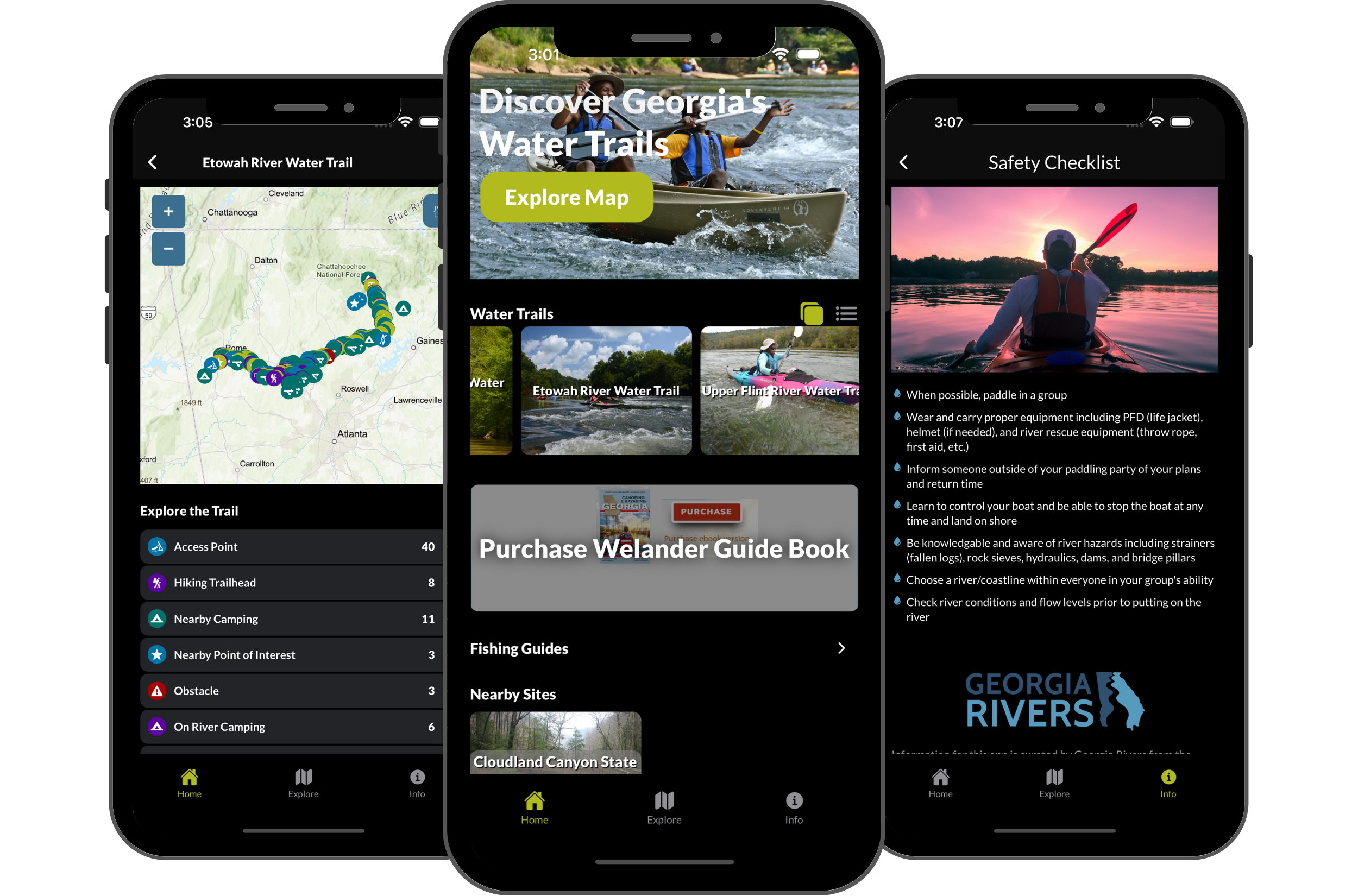
Georgia River Network’s work is devoted to protecting Georgia’s rivers, promoting water safety, and fostering stewardship among paddlers, advocates, and local communities. The Georgia River Guide app—made stronger through GeoMarvel’s Nonprofit Program—has rapidly evolved into a vital digital resource. By leveraging our dedicated professional services hours, the app now underpins a safer, more informed paddling experience: real-time river data, improved user interface for trip planning, seamless incident reporting, and robust platform infrastructure.
Our collaboration helped expand the range of available educational content, connected river advocates and recreational users, and provided tools to report and monitor river issues across the state. The Georgia River Network is now better equipped to scale outreach, support conservation action, and deepen real-world impact on water safety and environmental stewardship.
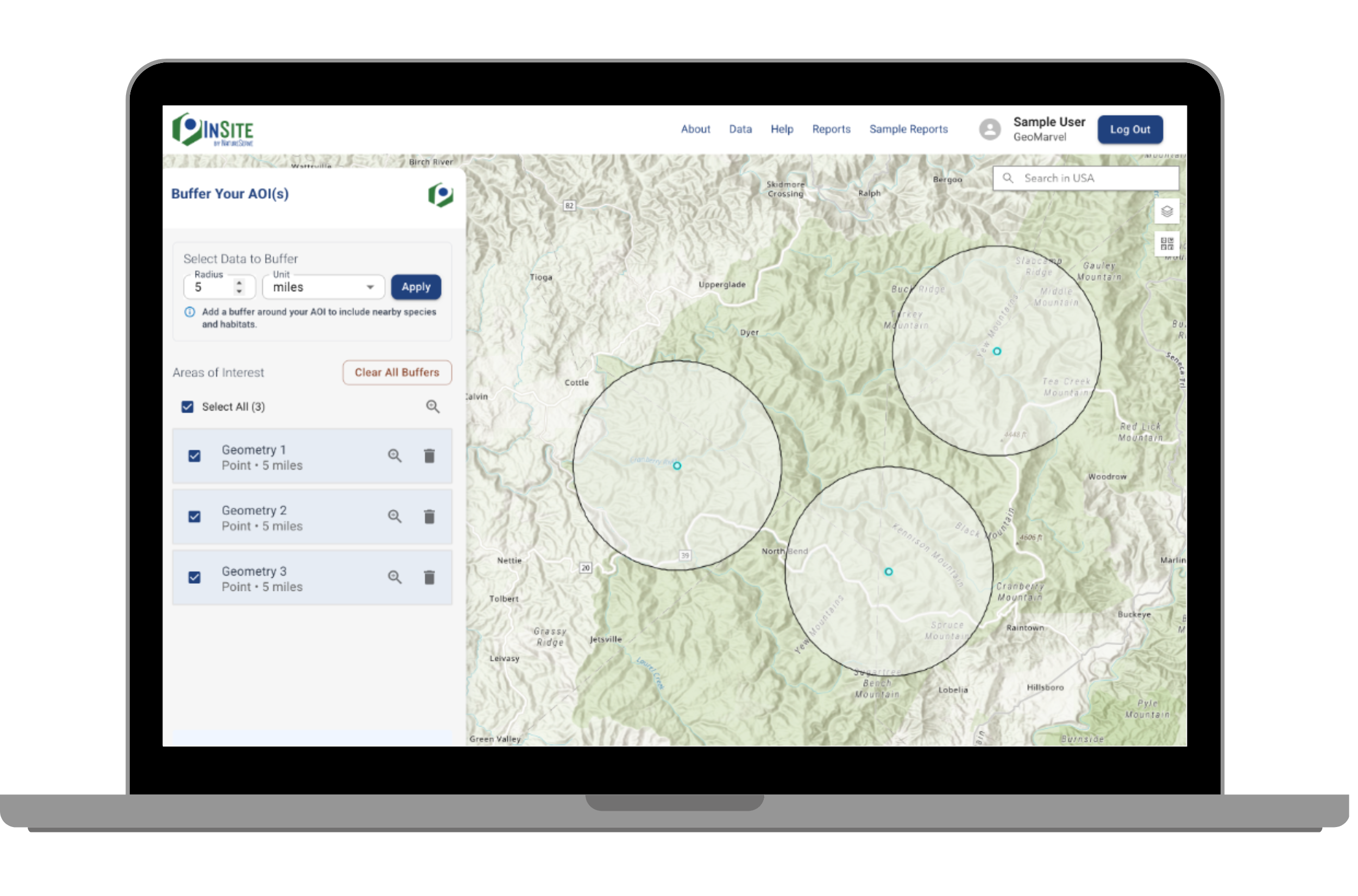
NatureServe stands at the intersection of data science, conservation, and public service—delivering the analytical underpinnings for biodiversity and land management decisions nationwide. Through a close partnership with GeoMarvel and our Nonprofit Program, these capabilities have coalesced into the custom-developed Insite Biodiversity Tool. This application builds upon the NatureServe Biodiversity Values Site Report, now empowering land managers, planners, and conservationists with secure, powerful tools for evaluating lands at scale.
The project focused on system architecture, Esri ArcGIS integration, and workflow automation, ensuring reliable analytics and seamless access to actionable data. Today, the Insite Biodiversity Tool offers scalable biodiversity scoring, downloadable site reports, and integrated mapping tools that support both local and national conservation programs. By strengthening the technical foundation and expanding reporting capabilities, NatureServe delivers better outcomes for those entrusted with protecting invaluable natural resources.
Holding the Esri Nonprofit Specialty Badge distinguishes GeoMarvel as a trusted leader among Esri Business Partners in the nonprofit GIS sector. This designation is awarded to partners who:
For nonprofits, the Esri Nonprofit Specialty means it’s easier than ever to find a partner who truly understands unique organization needs and can leverage ArcGIS tools efficiently and affordably to fuel impact.
GeoMarvel’s Nonprofit Program is about more than technical support—it’s a commitment to investing in the organizations, leaders, and ideas that leverage technology and location intelligence for lasting social value. As the inaugural projects near completion, anticipation builds for new mission-driven partners to join in the coming year.
Eligible nonprofits of all types—environmental, health, social, educational, public safety—are invited to envision how professional services, digital solutions, and infrastructure enhancements can fuel their missions in 2026 and beyond.
GeoMarvel congratulates Georgia River Network & NatureServe and extends an invitation to nonprofits ready to transform their missions with advanced geospatial tools & expertise. The journey starts here—together, let’s chart a path toward more connected, safer, & impactful communities.
GeoMarvel is committed to walking side by side with mission-driven organizations as the Nonprofit Program grows and evolves. Complete our application below to submit your organization for consideration & thank you for your interest.
Our team of GIS systems experts are fully equipped to aid your organization with all of your ArcGIS Enterprise implementation and migration needs, from on-prem to cloud infrastructure, we’re here to help you keep in line with industry best practices and to ensure a healthy & fully operational GIS system to support your critical workflows. We offer a variety of service packages, including the building of GIS cloud infrastructures, cloud hosting strategies, technical consulting, Managed Services, and much more. Here at GeoMarvel, we are committed to providing our clients with comprehensive GIS support and knowledge transfer, to empower them with complete GIS systems to achieve their goals!