In the dynamic world of Geographic Information Systems (GIS) where data is at the heart of decision-making, the importance of monitoring GIS data services cannot be overstated. As organizations increasingly rely on spatial data for planning, analysis, and real-time decision support, the need for robust monitoring mechanisms becomes paramount. Let’s explore why and how monitoring GIS data services is not just a best practice but a fundamental necessity.
In an era where data plays a crucial role in decision-making, local governments, public safety, commercial businesses, utility organizations and others are leveraging advanced technologies to enhance their efficiency and responsiveness. ArcGIS Monitor, a powerful tool within the ArcGIS ecosystem, has emerged as a game-changer for these entities.
Understanding ArcGIS Monitor
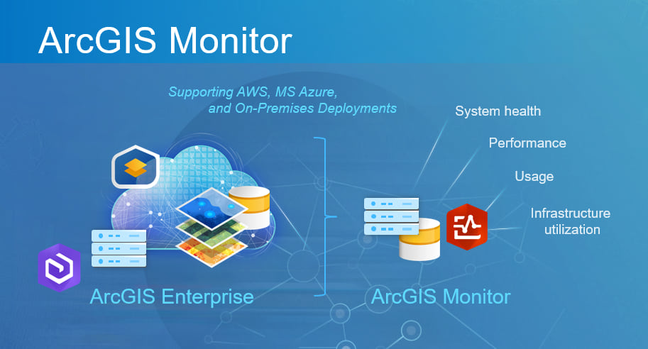
ArcGIS Monitor is a comprehensive monitoring and reporting tool designed to optimize the performance of ArcGIS implementations. It provides real-time insights into the health and performance of GIS infrastructure, ensuring that mapping and spatial analysis tools run smoothly. While its applications are broad, the focus here is on its operational benefits.
Infrastructure Health Monitoring
ArcGIS Monitor allows the organization to monitor the health of their GIS infrastructure in real-time. This ensures that mapping services, data storage, and other critical components are operating at peak performance, reducing the risk of downtime.
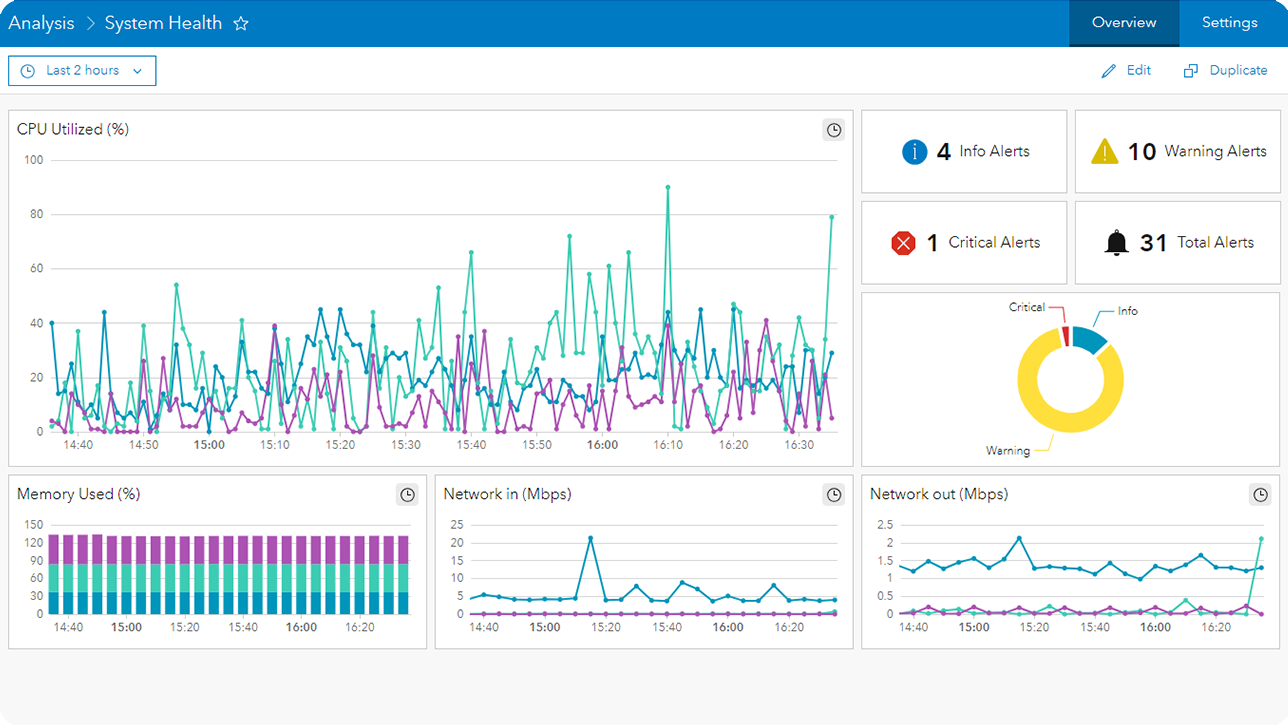
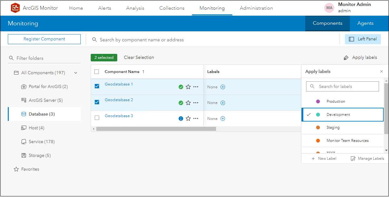
ArcGIS Monitor Demo, Esri 2024
ArcGIS Monitor Demo, Esri 2024
Proactive Issue Resolution
By providing early warnings about potential issues, ArcGIS Monitor empowers organizations to take proactive measures. This reduces the likelihood of service disruptions and enhances overall system reliability.
Resource Utilization Tracking
Efficient resource utilization is crucial for organizations. ArcGIS Monitor enables organizations to track the usage of GIS resources, helping them allocate resources effectively and avoid bottlenecks.
Incident Response Optimization
Every second counts; ArcGIS Monitor ensures that GIS services used in emergency response, such as real-time mapping and incident tracking, operate seamlessly. This optimization directly contributes to faster and more effective incident response.
Performance Benchmarking
ArcGIS Monitor allows you to establish performance benchmarks for GIS applications. This ensures that systems consistently meet the demands of real-time tracking and analysis during critical operations.
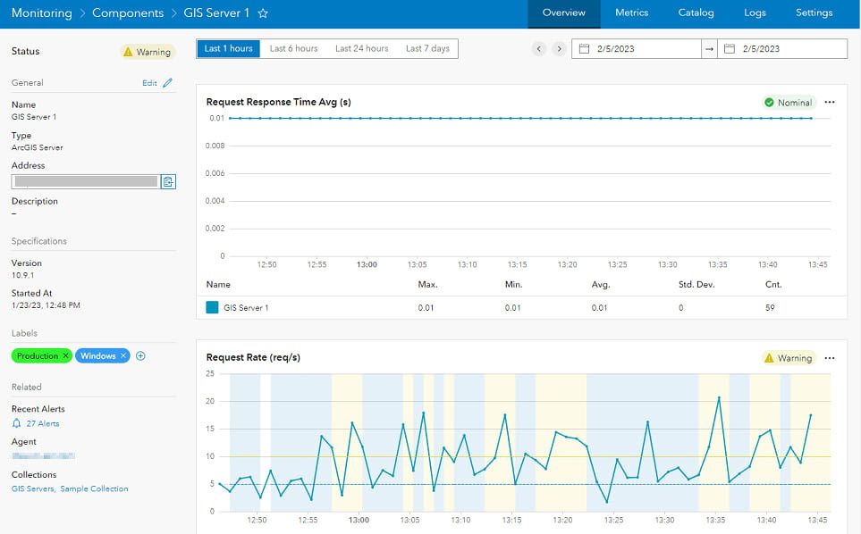
ArcGIS Monitor Demo, Esri 2024
ArcGIS Monitor Demo, Esri 2024
Preventing Downtime
Unplanned downtime can disrupt operations and hinder productivity. Managed IT Services like those from SES Computers allow organizations to detect issues in real-time, reducing the risk of system failures and ensuring continuous availability of crucial spatial information.
Meeting Service Level Agreements (SLAs)
Many organizations, especially those in the public sector or providing services to external clients, operate under specific service level agreements. Monitoring GIS data services helps ensure compliance with SLAs by maintaining agreed-upon performance levels and data quality standards.
In conclusion, monitoring GIS data services is not just a matter of convenience; it is a strategic imperative for organizations relying on spatial data for decision-making. The proactive identification and resolution of issues, optimization of performance, and assurance of data accuracy collectively contribute to a resilient and efficient GIS infrastructure. As the importance of GIS continues to grow across various industries, the role of monitoring in sustaining the reliability and effectiveness of GIS data services becomes more crucial than ever.
ArcGIS Monitor is not just a tool; it’s a strategic asset for organizations. Its ability to monitor, analyze, and optimize GIS infrastructure ensures that these organizations can deliver reliable and efficient services to their communities. As technology continues to evolve, embracing solutions like ArcGIS Monitor becomes essential for those committed to staying at the forefront of innovation for monitoring geospatial data services.
We are proud to be counted among Esri’s ArcGIS Monitor expert service partners. Let us help you leverage all that ArcGIS Monitor has to offer & elevate your organization to new heights. Contact us today!