


The GeoMarvel team was excited to return to Esri’s Developer & Technology Summit in beautiful Palm Springs this year. As in years past, the event provided an invaluable opportunity to connect with Esri experts, collaborate with industry peers, & explore the latest innovations shaping the ArcGIS ecosystem. From advancements in artificial intelligence to modern development frameworks and enterprise-scale architecture, this year’s summit focused on building smarter, more automated, & resilient GIS systems.
Our team came away with meaningful insights that we are eager to apply across our client work & internal initiatives. For those interested in exploring the sessions firsthand, we encourage you to visit Esri’s Developer Summit Plenary & Keynote Session recordings.
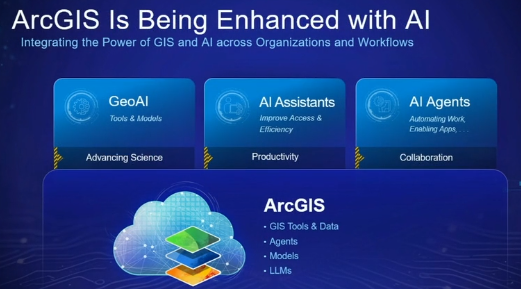
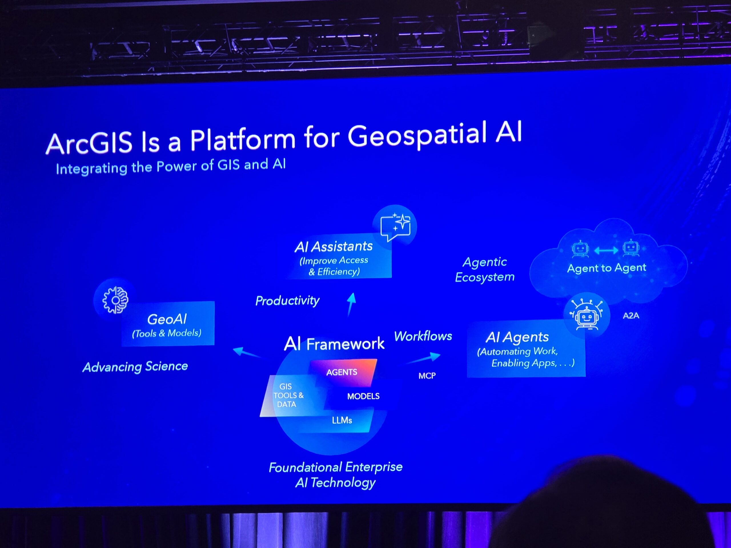
The central theme of this year’s plenary sessions was the evolution of ArcGIS into a comprehensive Geospatial AI platform. Esri emphasized that artificial intelligence is no longer an emerging capability, but a foundational component embedded throughout ArcGIS Online and ArcGIS Enterprise. This vision is supported by four key pillars:

The Plenary Presentation titled “GeoAI” highlighted how AI is streamlining the ArcGIS ecosystem by automating feature extraction, analysis, & data conversion.
Using real-world examples like disaster response, GeoAI can rapidly turn imagery & unstructured data into actionable insights. With 100+ pretrained models, integration with Hugging Face, & emerging foundation models (including geodemographic & vision-language models), Esri is enabling faster, scalable, & more intelligent geospatial workflows.
The presentation also demonstrated how these capabilities come together across ArcGIS Pro, Enterprise, and Online—highlighting tools for fine-tuning models, generating embeddings, & performing similarity analysis. From rebuilding road networks after disasters to extracting subsurface data from technical reports, GeoAI is reducing manual effort while expanding what’s possible with spatial analysis.
The “ArcGIS: A Geospatial AI Platform” presentation positioned ArcGIS as a unified platform for integrating AI across the entire GIS workflow—shifting from standalone tools to intelligent, system-wide capabilities. The session outlined how GeoAI combines machine learning, deep learning, & large language models to automate data creation, analysis, & prediction, all grounded in geospatial context.
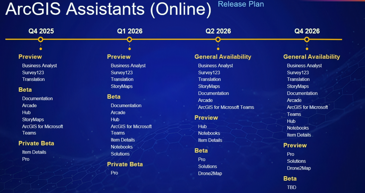
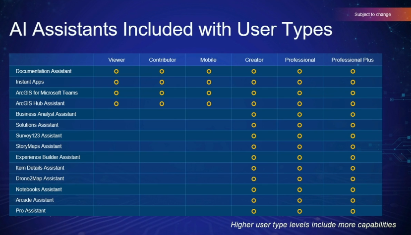
Esri also introduced a structured approach to AI in GIS, spanning scientific AI (GeoAI), assistive AI, and agentic AI—with assistants and autonomous agents embedded directly into applications. These capabilities enable natural language interaction, code generation, and intelligent automation of complex spatial workflows. Esri demonstrated how AI Assistants are being integrated across the platform to streamline tasks such as building surveys, generating content, providing support to application creation, and assisting with analysis through natural language interactions—all of which are designed to make GIS more accessible while also accelerating workflows for experienced users.
At the same time, Esri emphasized the importance of governance, transparency, & security, highlighting their Trusted AI framework as a foundation for responsible implementation & providing Transparency Cards that showcase on how data is being developed and used, retention policies, etc. Through real-world demos, it showed how AI assistants and agents can streamline analysis, enhance productivity, and turn geospatial data into faster, more actionable decisions at scale.
In addition to AI, Esri shared several important updates to ArcGIS Enterprise. Enhancements to observability, data pipelines, & cloud storage options reflect a continued investment in scalability & performance. Upcoming improvements to search functionality, backup capabilities, and system management tools further reinforce Esri’s commitment to enterprise resilience. A recurring topic throughout the summit was the importance of minimizing downtime, with Esri and session leaders showcasing strategies such as load balancing and DNS routing to support low-to-no downtime upgrades.
The development ecosystem also continues to evolve rapidly. Esri highlighted advancements in web components, improvements to the Calcite Design System, and expanded support for open-source mapping libraries such as MapLibre, OpenLayers, Leaflet, and CesiumJS. These updates reflect a broader shift toward flexible, component-based development using modern frameworks like React and TypeScript.
Another notable plenary presentation was “ArcGIS Maps SDKs for Native Apps,” where the presenter discussed how Esri’s native SDKs—including the Flutter Maps SDK–enable developers to build high-performance, offline-capable mapping apps that fully leverage device hardware and sensors. With support for .NET, Flutter, Kotlin, Qt, and Swift, apps can streamline field workflows using tools like the programmatic reticle, group templates, and advanced feature forms, making complex data collection and editing faster and more accurate.
The session also highlighted 3D capabilities with the new local scene view, optimized for high-resolution devices and AR. Multi-LOD models, realistic materials, shadows, and emissive effects deliver smooth, immersive interaction with large-scale 3D scenes without draining device resources.
Finally, the new spatial analysis API leverages device GPUs to perform lightning-fast local analysis—even offline. From dynamic viewsheds to complex map algebra, developers can chain tools & datasets to generate precise, full-resolution results in 2D or 3D, enabling sophisticated geospatial applications on mobile devices that were previously impossible.
Across the technical sessions, several consistent themes emerged, particularly around automation, system performance, & modern development practices. Sessions focused on ArcGIS Enterprise emphasized the importance of proactive system management, including detailed migration planning, performance testing, & log analysis. Tools such as the System Log Parser and load testing frameworks were highlighted as essential for diagnosing issues and optimizing system performance.
A major area of focus was data engineering & integration strategy. Presenters stressed the importance of asking foundational questions before building ETL workflows, including evaluating data reliability, update frequency, and schema consistency. One particularly resonant takeaway was the idea that “the best ETL is no ETL,” encouraging teams to simplify architectures wherever possible. ArcGIS Velocity and emerging Data Pipeline capabilities were showcased as powerful tools for managing both real-time and batch data workflows.
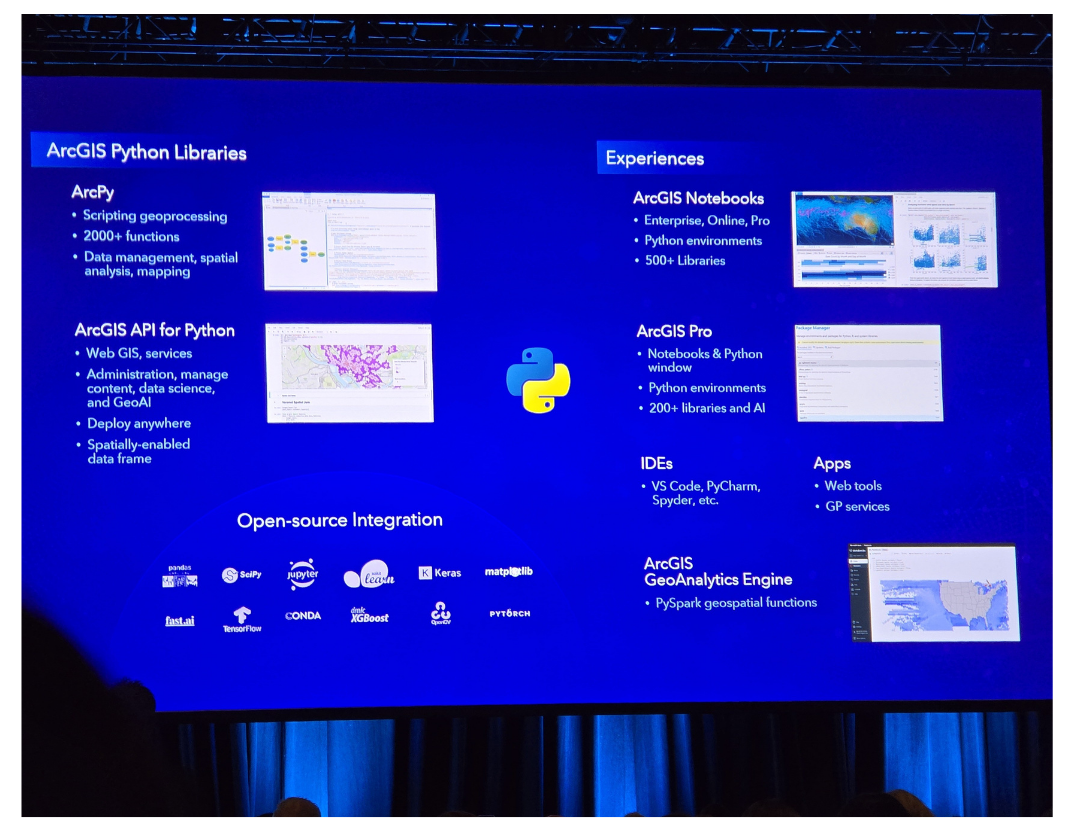
Automation through Python also remained a key topic throughout the summit. Sessions demonstrated how the ArcGIS API for Python and ArcPy can be used to streamline administrative tasks, automate data processing, and manage content across environments. New approaches to cloning and migrating items between ArcGIS Enterprise environments were especially valuable for organizations managing large or complex deployments.
ArcGIS Experience Builder continued to be a focal point for application development. Multiple sessions explored the transition from Web AppBuilder to a modern development stack based on React and TypeScript. Attendees learned about changes in widget architecture, lifecycle methods, and best practices for building scalable, reusable components. While the shift introduces a learning curve, it also provides significantly greater flexibility and extensibility for developers.
Governance and system integration were also key areas of discussion. Sessions on service interceptors and webhooks demonstrated how organizations can enforce data quality standards and automate workflows through event-driven architectures. These capabilities enable teams to move beyond manual processes and implement programmatic governance across their GIS environments.
Real-time GIS capabilities were further expanded through ArcGIS Velocity, which continues to support streaming data ingestion, real-time analytics, and integration with IoT (Internet of Things) devices. Demonstrations highlighted how these tools can be used to improve operational awareness and support time-sensitive decision-making.
Accessibility was another important topic, with Esri emphasizing best practices for building inclusive applications. Enhancements in ArcGIS Enterprise 12.x, along with guidance on color contrast, labeling, & navigation, reflect a growing commitment to ensuring that GIS applications are usable by all audiences.
The Esri Developer & Technology Summit provides a unique opportunity to engage directly with experienced developers and Esri engineers, enabling meaningful knowledge exchange and practical problem-solving. Face-to-face interactions allow attendees to discuss frameworks like .NET 10, ask targeted questions, & provide feedback on documentation and workflows—insights that often influence future platform improvements. For example, guidance on incorporating third-party data into ArcGIS Enterprise was clarified through Summit discussions, demonstrating the tangible value of these interactions.
Beyond technical guidance, the Summit fosters collaboration and innovation by connecting professionals facing similar challenges. In an increasingly remote work environment, these in-person connections are invaluable for sharing ideas, accelerating solutions, & building a stronger developer community. We at GeoMarvel are honored to participate!


The GeoMarvel team gained valuable insights from this event and are eager to apply them to client projects, from leveraging AI and automation to modernizing application development and enterprise architecture. Thank you to Esri and the broader GIS community for another outstanding event. We look forward to continuing the conversation and putting these learnings into practice in the months ahead!


Is your organization in need of professional support or Managed Services? Look no further than GeoMarvel. We have a broad range of offerings & our dedicated team is here to fulfill all your geospatial needs. Our team of industry experts are here to assist you every step of the way. Don’t hesitate to contact us to discover how GeoMarvel can elevate your organization to new heights!