
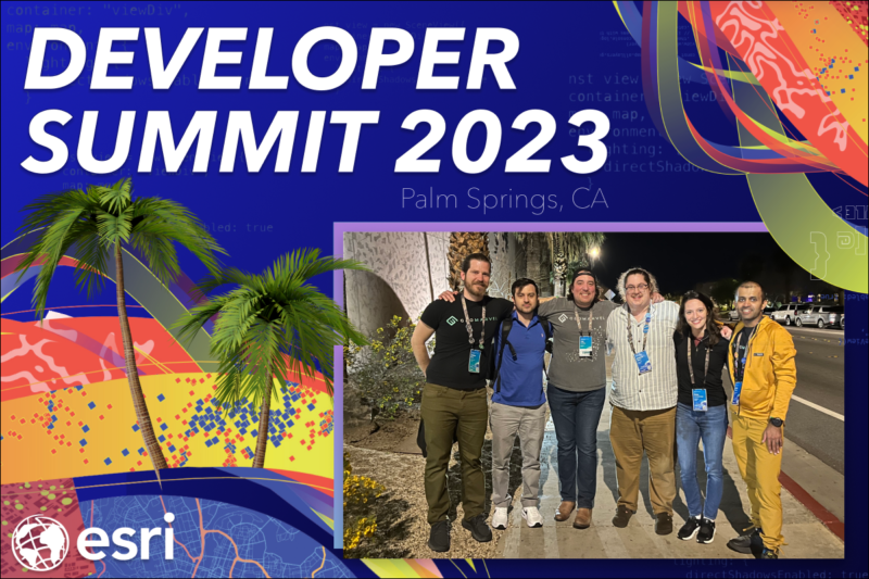
The GeoMarvel team was thrilled to return to Esri’s Developer Summit (Dev Summit) in Palm Springs this year! As in years past, our team gathered many important learnings, insights, & connected with many other attendees to get as much from the experience as possible and in turn, share with the rest of our team. This annual event is an amazing opportunity for industry leaders & GIS professionals from around the world to connect, collaborate, and learn more about how GIS technology is evolving and having an impact on the world around us. We encourage you to visit Esri’s Dev Summit 2024 Plenary Playlist to see all of the engaging & informative presentations for yourself.
At this year’s conference, the GeoMarvel team was represented by team members: Kevin Cheriyan, Sean Spiesman, Alden Grosh, Dalton Bloom, and Jon Nordling. Our team members attended many different technical & hands-on training sessions and even spoke with different Esri experts and industry leaders. Below we’ll share some of the highlights & key takeaways from the conference as well as provide resources so you too can benefit from the information provided.
A central theme to Esri’s 2024 Dev Summit was certainly Artificial Intelligence (AI) and how to leverage it in combination with ArcGIS & mapping tools. We were thrilled to learn that a Smart Mapping assistant will be released for ArcGIS Online (AGOL) in the near future, making AGOL so much more accessible to non-professionals. Attendees also got to hear about newer generative AI capabilities. These days, computers are capable of remarkable human-like communication as well as digital art! As far as the GIS industry is concerned, GeoAI for ArcGIS Pro is an exciting development, as it combines AI with geospatial data to help users perceive patterns, relationships, perform predictive analysis, and overall enrich your geospatial data.

Image from Esri Dev Summit 2024
The process that makes this possible can be described in these five steps: 1) See, 2) Analyze, 3) Read, 4) Learn, 5) Create. Though conceptually simple, the results are powerful once put into action: vector data analysis, classification, improved visual clarity for images, and more.
Esri also highlighted that they have over 70 pretrained AI models for imagery, 3D, and text on the ArcGIS Living Atlas available for use as is or they can be utilized to create your own model(s). One particular model of interest is SAM or the “Segment Anything Model.”
SAM is a deep learning model from Meta AI available in the ArcGIS Living Atlas and was cited as the most popular model ever and it’s not hard to understand why. SAM is able to classify and segment objects at the pixel level, honing in on objects that appear distinct from the rest of the background. In the case of aerial or satellite imagery, this includes things like bodies of water, agricultural fields, vehicles and watercraft, roads, and so much more. However, to take the next step of feature extraction, Text SAM can be leveraged to tell SAM what feature to target using text prompts. Text SAM is an open source sample model released by Esri in March 2024. A helpful feature of Text SAM is that what a user enters does not have to be the formal name of an object. In some cases, this information is unknown even to the user. A user can type in adjectives to describe the object (think color, shape, and material) and this will suffice for SAM to identify the objects in the image.
There was also a plenary presentation on ArcGIS Maps SDKs for Game Engines where the presenters demonstrated how to build an immersive GIS experience using game engine SDKs (Unreal Engine) on a desktop application, allowing users to create a to-scale 3D render of real-world structures & their surrounding areas. These visualizations include ArcGIS scene layers and feature data like stairways & air ducts for a newly constructed building. In the latter half of the presentation, there was also a demonstration using the Magic Leap 2 (augmented reality) and HTC Vive XR headset (virtual reality), that brought the desktop visualization to life through the device’s lenses. In other words, augmented reality provides users with the capability to see different layers superimposed over a real-world scene, whereas the virtual reality experience provides users with an immersive experience within a digital twin. Both capabilities are invaluable for emergency response planning, both in a training capacity and real-time emergency. Such technologies can help inform first responders on the most efficient & timely path to an individual in need of medical assistance.
Esri also announced that Maps SDK for Java will be deprecated in November 2024, which they clarified is separate from ArcGIS Enterprise SDK and will not be affected by this deprecation. They assured attendees that they will continue to support the use of Java with ArcGIS, given how widely utilized it is for web services and enterprise development.
Following the announcement of the Maps SDK for Java deprecation was the announcement of an April 2024 beta release for ArcGIS Maps SDK for Flutter. Created by Google about ten years ago, Flutter is an open source technology powered by Dart (a C-style syntax programming language). This cross-platform framework allows developers to build apps for multiple platforms from a single codebase. Finally, Esri also announced the release of ArcGIS Knowledge Studio in May 2024, a new extension for ArcGIS Enterprise. ArcGIS Knowledge Studio is a web application that allows users to create relationship diagrams between real-world objects, concepts, and events and is not limited to spatial data alone.
Prior to the conference, our attending team members devised a “divide and conquer” approach, ensuring that each team member would attend sessions critical to their current projects, client work, and grow our collective knowledge in different areas while minimizing overlap. We’ll share a bit more about each team member’s primary focus and specific sessions of interest.
Additional Resources

Senior Application Developer Kevin Cheriyan prioritized technical sessions & conversations with lead developers concerning ArcGIS Map SDKs for Native Apps & .NET. A few key learnings:
Kevin also attended a very interesting session titled ArcGIS Pro and Chat GPT: Making your Workflow Smart where the presenter showed how to create an ArcGIS Pro plugin using ChatGPT alongside ArcGIS Pro SDK & .NET. ChatGPT was leveraged to help generate Arcade expressions from ArcGIS Pro data, which removes technological knowledge as a prerequisite to write them–the user need only ask the right questions to obtain the desired result.
Application Developer Sean Spiesman attended some of the aforementioned ArcGIS Maps SDK for .NET sessions but his focus was more on web development and ArcGIS Maps SDK for Javascript, as he and many of our other developers utilize it on a daily basis. Sean noted the emphasis of utilizing AI in web development and also attended a session where ChatGPT was utilized. Their examples were in a supply chain context and the AI was asked how to perform a task in the most cost-effective manner based on data provided by the user and also to identify compromised locations for various reasons. While the AI scrapes through web information at an astonishing speed, can provide helpful insights, and help users save time on various tasks, it is important to note that this technology is not perfect and is constantly evolving. Users should be aware that there are sometimes errors and miscalculations and that was also demonstrated in this session.
Alden Grosh, an Enterprise Solution Engineer on our Managed Services team, focused on ArcGIS Enterprise presentations. There were several sessions regarding ArcGIS Survey123 that also incorporated using AI assistants. For ArcGIS Survey123, presenters showcased how the AI assistant can be trained to build your surveys for you or even redact people’s faces in field applications. GeoAI for ArcGIS Pro, as referenced in the above Plenary Highlights, is the combination of AI with geospatial data to help users perceive patterns, relational data, perform predictive analysis, and take your geospatial data to the next level. Esri also shared the recommended order of upgrades for ArcGIS Enterprise and different ways to perform upgrades. Alden also attended the session entitled ArcGIS Experience Builder: Building Your First Widget where React and Typescript were used to build a widget and attendees were given debugging tips to help improve the user experience.
We are pleased that our team came away with a plethora of information from Esri’s Developer Summit and was able to impart that knowledge to the rest of our team. We’re looking forward to attending again in the future and applying this year’s learnings to our client projects, services, and supporting their diverse business needs. Thank you Esri & partners for another successful & rich conference!
Is your organization in need of professional support or Managed Services? Look no further than GeoMarvel. We have a broad range of offerings & our dedicated team is here to fulfill all your geospatial needs. Our team of industry experts are here to assist you every step of the way. Don’t hesitate to contact us to discover how GeoMarvel can elevate your organization to new heights!